You can’t get there from here

Apparently in Maine they have a saying, “you can’t get there from here” (spoken in a Maine accent), said when giving directions as an observation of the impossibility of traveling a direct route between certain places. It seems to have something to do with lakes and the organization of roads in the vast rural areas of the state. To some extent it also holds true in other parts of New England.

I have been learning my way around the Boston area for some fifteen months now, and I do not wish to suggest that the challenge in an urban area measures up to what the good people of rural Maine face, but I think of the phrase often as I’m puzzled by how to drive between two points in town. Compared to most American cities, the street network here can be rather chaotic, and absurdly simple trips like driving across a street or around the corner can require a convoluted route and an intimate knowledge of the local streets. It’s just another good reason to leave the car at home.

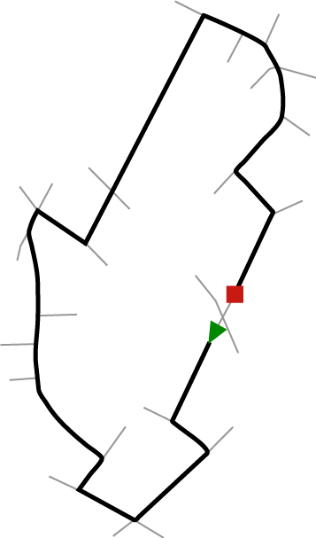
Anyway, while spending some time dreading getting in the car to finish a bit of Christmas shopping, I was curious to see what some of these ridiculous routes look like on a map. Here are a few of the not-so-simple paths required for simple trips in and around Boston. Bits of intersecting streets are shown to illustrate that there’s no such thing as just going around the block.
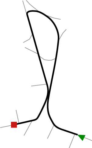
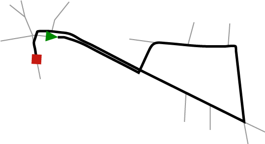
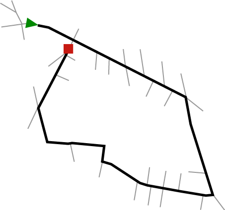
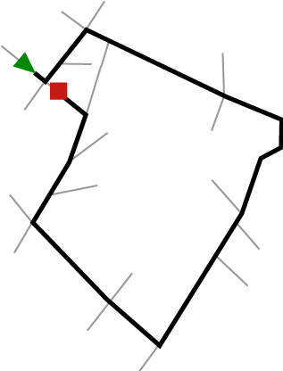
You can't get there from here - Harvard Square

You can't get there from here - Union Square, Somerville

You can't get there from here - Union Square, Somerville

You can't get there from here - North End

You can't get there from here - City Square, Charlestown

Bring GPS.

Tagged , , ,

38 Comments

  1. Hehe, you should visit Europe… πŸ™‚

    Simon
    23 December 2009 @ 7:16am

  2. Really enjoyed this post!

    Dave
    23 December 2009 @ 9:10am

  3. Indeed, Simon, with Europe in mind I was extra careful to indicate that Boston is particularly difficult among American cities. I will certainly bow to my European masters of urban navigation!

    Andy Woodruff
    23 December 2009 @ 10:01am

  4. If it wasn’t winter in Boston, I’d suggest changing the topology by walking for several of those journeys.

    JWinOC
    23 December 2009 @ 11:01am

  5. Oh, walking is still smarter, even in winter!

    Andy Woodruff
    23 December 2009 @ 11:13am

  6. Is the third one here actually union square? The caption says it is but I cannot figure out where in union square that would be.

    mike n
    24 December 2009 @ 9:03am

  7. Mike, yeah, it’s sort of a large loop starting and ending around Union Square. It runs along Somerville Ave all the way to Medford St, then makes its way over to Prospect St, ending back near Somerville Ave.

    Andy Woodruff
    24 December 2009 @ 10:47am

  8. ahhh, very nice.

    mike n
    27 December 2009 @ 7:47pm

  9. I think Boston is even worse than European cities. As long as I had a map (doesnt have to be in English), I’ve made my way around cities in over 50 countries worldwide. But two years of business school in Boston, and I would *still* get lost on the way to the grocery store.

    I think European cities have been regularly flattened by way often enough that they are rebuilt slightly more sensibly each time. Boston has centuries of kruftiness built in.

    great post!

    marc cenedella
    28 December 2009 @ 4:43pm

  10. You can simplify some of those routes with a higher tolerance for breaking the law. I pull that illegal U-turn in #1 all the time rather than go all the way around.

    patrick
    29 December 2009 @ 11:23am

  11. @6:

    There are some streets missing.

    I think the green arrow is on somerville ave. eastbound, and then driving to Medford Ave (right by 28), going under the railroad tracks, turning right onto south st. westbound, then back up to prospect st. to cross over the tracks to end up across from the dunkin donuts (is that an autobody shop?)

    Joe
    29 December 2009 @ 3:07pm

  12. Joe: Yes indeed, that’s the route. No streets missing exactly; I’m only showing little spurs from the points of intersection with the main route and deliberately ignoring everything else.

    Patrick: Oh sure, if you consider the reality of how people drive in Boston, the routes do become simpler…

    Andy Woodruff
    29 December 2009 @ 10:44pm

  13. Amen. Having grown up in northern Maine (Presque Isle) and spent a few years in Boston, I can vouch that neither is made for cars. You’re better off for most of the year on a snowmobile (Maine) or on foot (Boston).

    I’ve had to explain to more than a few Texans (where I currently reside), who thought I had just missed my turn, the finer points of making a ‘jug-handle’ – turning left by making three rights.

    Luke
    30 December 2009 @ 5:23pm

  14. I live near you (Kenwood and Allston) in Cambridgeport. I’m the webmaster of the Charles River Wheelmen, and an avid cyclist. If you’re ever willing to ride your bike more than 4 times a year, I’d be willing to show you more quirky “cant get there from here” routes. You should take me up on this.
    – Gary Smiley

    Gary Smiley
    23 January 2010 @ 6:57pm

  15. This is a bit long-winded for a comment (for which, apologies), but the piece in the 1/24/10 Globe (taken from this great blog post) reminded me of an exchange I had nine years ago. I had seen the following complaint on a listserv:

    “A major contributor to the development of such horrible attitudes of Boston area drivers: The roads themselves. We all know what a nonsensical jumble of side streets, swirling on and off ramps, congested tunnels and strangely located one way roads are offered by Boston. The screwy road system leads to a “kill or be killed” mentality. Even long time residents don’t fully understand it all–I pity new residents with cars.”

    My response:

    “Why so historically and architecturally insensitive? Not just because it’s already the 21st century and you think the world was created anew at the bicentennial when you were born, I hope. The streets may be a jumble, but it’s not “nonsensical” at all. Thinking so keeps you from appreciating the city as an organic creature and understanding the process by which the old does or does not give way to the new.

    “If you find a map of the Shawmut peninsula, ca. 1634 when Boston was founded, you will see that it was shaped something like a tadpole with three quite tall hills at the center and northwest (Mt. Vernon, Beacon Hill and Cotton, or Pemberton, Hill), whence comes “Tremont.” The only connection to the mainland was a narrow isthmus following where Washington Street now lies and running approximately from the present Chinatown (the south end of the tadpole) through saltmarshes to what is now Roxbury where (if you drive along Blue Hill Avenue and the surrounding area, you will see)the marshes gave way to higher ground. Remember the painting of General Washington at the battle for Dorchester? He’s on the high ground overlooking those marshes.

    “The roads (and, later, streets) that were built on the peninsula in the beginning took the settlers from important places as directly as possible to other important places, but they had to curve along the shoreline, or around those hills. Occasionally the most direct route lay across another route, perhaps at an acute angle.

    “Now look at maps of the city at the end of the 18th c. and then during the 19th c. You will see the tadpole expanding in several directions. Mount Vernon was cut down to make way for Charles Street. The peak of Beacon Hill was cut off and used to fill the Mill Pond, which lay roughly between Hanover, Sudbury, and Causeway Streets (i.e., where the Big Dig is now pushing from Haymarket up to North Station) in the 1820s. Patrick Tracy Jackson, one of the founders of the textile mills in Lowell (and thus of the American Industrial Revolution) purchased much of Pemberton Hill. In 1835, using β€œ126 oxen, 60 Yankees, and 199 Irishmen,” he carted the top sixty-five feet of Pemberton Hill to the Charles River north of Causeway Street at approximately the site of North Station, where it filled eight acres to a depth of fourteen feet. One reason why most of the streets on the northwest side of (current) Beacon Hill are more or less straight and intersect at right angles is because the new buildable land there was created more or less at once.

    “Originally, everything west of what is now Charles Street was tidal marshes (the “Back Bay”). During the latter half of the 19th c., the Back Bay was completely filled in with fill brought in by railroad from what are now the western suburbs. Moreover, everything one now sees on either side of Washington Street and across to South Boston was filled slowly but surely. Long Wharf originally stretched way out into the harbor, but the land was filled in behind it, leaving only its name to suggest its former glory.

    “All this filling was done by individuals and individual businesses, working with whatever small piece of the big picture they had been able to grab.

    “As the former marshes and ocean were filled, the buildings were built — on the new land, as is where is. This was necessarily an opportunistic process: you build where the land is now, not where it isn’t yet. Where you build houses and businesses, roads follow, also opportunistically. To suggest that this should have been done with governmental authority and a master plan, (the logical extension of calling the present jumble
    “nonsensical”) is pretty nonsensical.

    “Once the city was filled in and built, well, there were the roads.

    “Since then, there have been precious few opportunities for government to impose a master plan on urban development and to change the routes of roads that in some cases have been curvy for 300 years, or to make right angles of intersections that have been at acute angles for 300 years. (You will, I hope, note that there are more such intersections in downtown Boston than in the Back Bay, for example, which was laid out by powerful interests who owned larger tracts of land and were, thus, able to make their streets more regular.) When city government has attempted to reduce the jumble, it has often had unhappy results. (Ask any native older than 55 about the West End.) Or it has only gone so far. (The Central Artery was never designed to carry ALL the north-south traffic. It was only half of a master plan that also included a ring road cutting more or less through the Back Bay and South End. Any guesses why that wasn’t built? Politics, i.e., lots of humans pushing and shoving and protecting what they’ve got, basically.)

    “So, my humble suggestion is that you may enjoy those frustrating times sitting in Boston traffic more if you look around you and visualize the process that led to what you actually see, and all the men and women who lived there and walked those same streets before you. Also, if you have a chance, read Walter Muir Whitehill’s “A Topographical History of Boston.”

    Matt Dallett
    24 January 2010 @ 10:44am

  16. Andy, nice post, was directed here via boston.com. As a former Mainer and current Bostonian, I have uttered this phrase more times then I care to admit. May I suggest potentially getting a set of prints made up for these?? I love incorporating local *stuff* (art, images, etc) into decorating at home and these would be so intriguing hanging on the wall down a hallway, or as drink coasters (for excellent cocktail conversation). Also, would love to see the word map of boston when it’s complete. Happy mapping!

    Alyssa
    25 January 2010 @ 9:44am

  17. Actually, “You can’t get there from here” has its origins in the New York subway system, implying that a person would have to change trains before arriving at their final destination.

    Steve Gluck
    19 September 2010 @ 10:32am

  18. Wonderful post. Most important were the drawings and I very much support Alyssa’s suggestion that you make prints since these are intriguing but tell a very important story that will probably take a thousand convoluted, no pun intended, words to explain. The drawings remind me to tell stories with simplicity without losing the complexity. I’m sure you’ve come across Charles Joseph Minard’s famous statistical graph on Napoleon’s 1812 Russian campaign. For others curious, it is here : http://www.edwardtufte.com/tufte/posters

    Sivaramakrishnan Balakrishnan
    2 December 2010 @ 2:54pm

  19. This reminds me of the ancient SNL skit “What’s the Best Way” – a game show consisting of New Englanders trying to give the best directions. It’s pretty hilarious – here’s the transcript: http://snltranscripts.jt.org/92/92ibestway.phtml can’t find the video though.

    awesomerobot
    5 May 2011 @ 2:35pm

  20. Ha! Love it. I’m tempted to sign up for a trial of the paid Hulu just to see if they have that sketch.

    Andy Woodruff
    5 May 2011 @ 2:56pm

  21. Just very interesting. I was writing a rant on my blog about the problem of navigating this city here: http://whatwebethinking.blogspot.com/2012/03/how-can-we-function-in-society-if-we.html

    In general I was just comparing Boston to New York. My roommate who is from Brooklyn comments on how much more willing people are to go somewhere in NY then they are here. Especially since Boston is much smaller than NYC, I was wondering how the design of our roads affect this. It’s just so hard to get around, and despite living here a while I get lost so easily both driving, trying to catch a bus or walking. Interesting browsing your website.

    Nate
    21 March 2012 @ 10:41pm

  22. I often wonder… what happened to all those families who stopped to ask directions and I sent off in the wrong way?

    Anyway, when I moved to Boston the other drivers used to make me crazy. Then one day I saw a bumper sticker that read “Don’t get upset, just drive like I do!” After that everything was fine.

    Ronnie
    29 July 2012 @ 4:53am

  23. I brought the GPS to Boston. It wanted me to make a left hand turn in a tunnel, then I got the snotty lady saying “recalculating”. What did she expect me to do?

    Wendy
    18 September 2012 @ 5:28pm

  24. I’d like to observe that a lot of the navigation “issues” are a result of one-way streets imposed to keep cars off of local streets. Since Boston doesn’t have a strong highway or wide-thoroughfare network, there are a lot of residential streets that would get you there faster than the main roads. However, since the local leadership view this as undesirable, a one-way “drainage” system is implemented to keep you out.

    I know this is the intention in Cambridge (between Cambridge Street and Hampshire Street), Inner Belt (east Somerville), Prospect Hill (Somerville). I guarantee there are many other places where a two lane road would suffice, but traffic would make the places less livable.

    Doug
    20 November 2012 @ 10:18am

  25. Just like rural Philippines. Usually you need to go the long way around a mountain. Sometimes you get out of your car, find someone to hire their boat, go a ways and then find a car to hire again. Maybe get out and walk a whiles, then, take a motorbike. Then….

    Mike Keller
    19 March 2013 @ 10:47am

  26. When I was about 17 years old we struck out from a camp site in Cornwall carrying heavy back packs. After walking all day in the hot sun we reached the sea and asked in the village for the nearest camp site. We were directed to climb a narrow path up the cliff that faced the sea. After another half hour we reached the camp and as we were walking towards reception I commented to my friend that this place must be owned by the same company as the place we camped last night because the buildings looked the same. Then we stared in amazement at the yellow spot on the grass where our tent had been pitched.

    Now that’s the long way round!

    Mike
    1 May 2013 @ 3:24am