Paint by numbers

Here’s something from the “Mildly Interesting” files. Address numbering schemes can vary a lot from place to place in the United States. In some cities the system is straightforward enough that by knowing a street number you can know approximately, if not exactly, the location of that address. In some other places… well, luckily addresses are all geocoded and easy to search for these days.

Beyond knowing the system or finding addresses, I was curious to see complete house numbering systems. I had ideas of colorful city maps representing street numbers from low to high, but my attempts failed to produce anything worthwhile because the range of numbers tends to be so great that it’s difficult to show patterns of any intricacy.

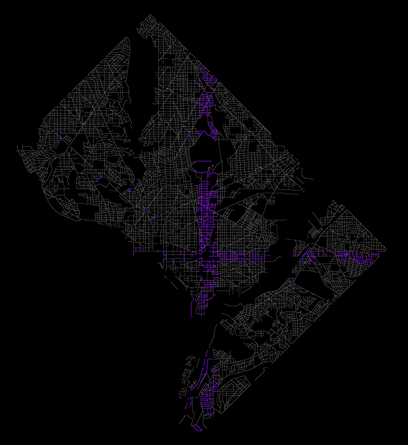
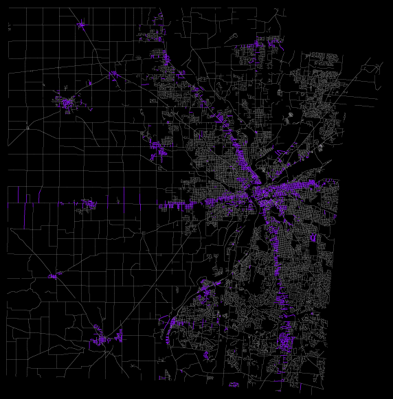
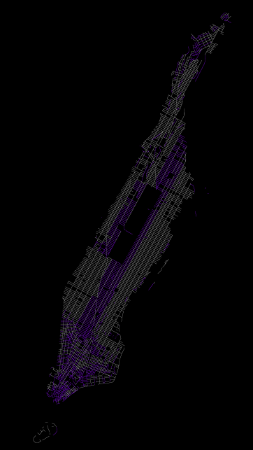
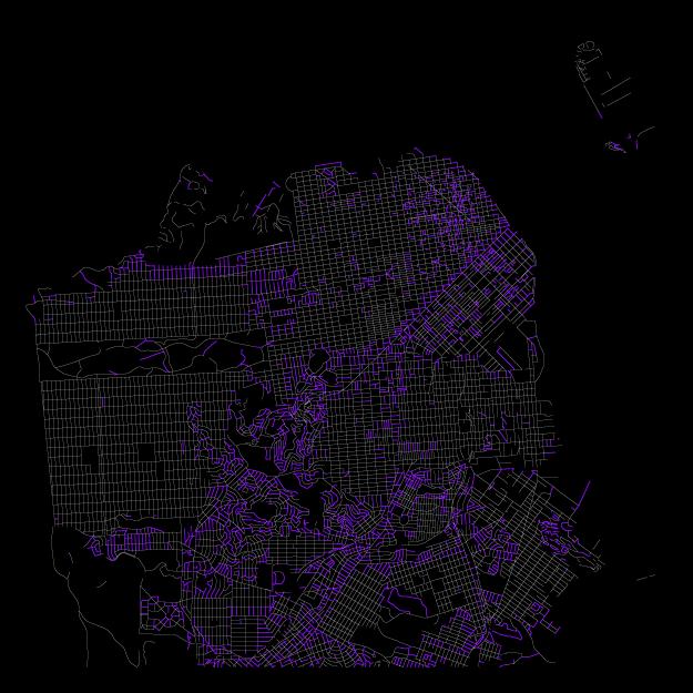
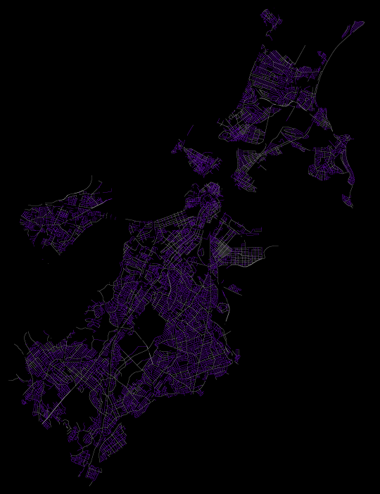
Instead, one can still get a sense of the house numbering scheme by looking at where the numbers begin. So I made a few maps to show that, based on the Census Bureau’s TIGER/Line files. Here are seven cities (the counties that contain them, actually, because that’s how the Census rolls), obviously not an extensive set nor likely representative, but showing a bit of variety. Purple blocks are those containing any numbers from 1 to 100.

Washington, DC: A perfect example of a system where numbers increase in north, south, east, and west directions from two central axes, in this case extending from the Capitol. In Washington’s case, the city is divided into quadrants. Chicago is another very orderly big city, but my computer is too weak to handle a map of all the streets in Cook County.
Washington street numbers

Atlanta: Atlanta is similarly divided into quadrants, but here streets are not as geometrically perfect, and I’m not sure if the axes always follow particular streets (or other features).
Atlanta street numbers

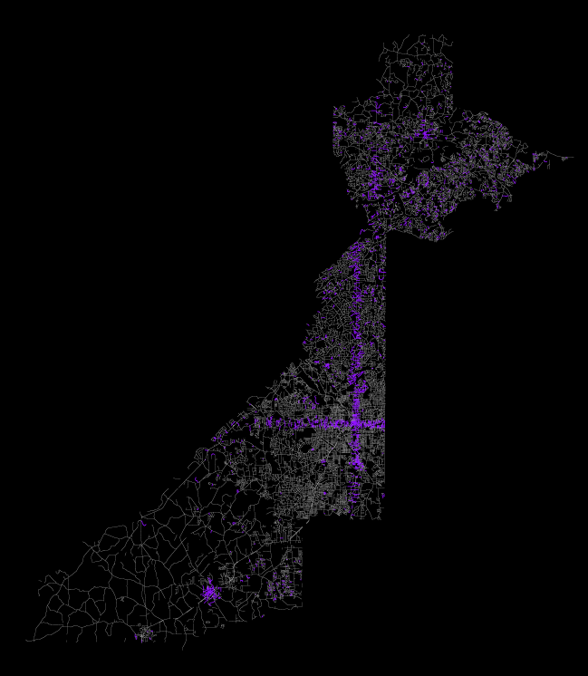
Dayton, Ohio: Had to check out my place of origin. Dayton bases its numbers not strictly on cardinal directions but (mostly) on the main north-south and east-west streets, which bend a bit. Meanwhile, the rural parts of Montgomery County appear to follow the same pattern, while individual towns do their own thing.
Dayton street numbers

New Orleans: I can’t really tell what’s going on here. There is the north-south divide on Canal Street, but I can’t discern what the baseline for other streets might be. Any locals out there who can explain?
New Orleans street numbers

Manhattan: Another well-organized system, with numbers counting upward from 5th Avenue (and Central Park, it looks like) and from downtown. Unlike many other places with gridded, numbered streets, the addresses don’t match the cross street number, not that you can see that in this map. I vaguely recall once seeing some kind of formula for determining which block a given address is on. Any links or confirmation would be wonderful!
Manhattan street numbers

San Francisco: What the hell? Wikipedia says there are different numbering systems within the city. You wacky left-coasters.
San Francisco street numbers

Boston: I’m not saying things are so much neater over here. Boston and presumably much of New England keep it simple. Numbers just count upward from the beginning of the street, wherever that may be. (I’m not actually sure which end of the street is favored for the beginning; I know my street in Cambridge starts from the north.) Being the jumbled mess that it is, Boston doesn’t have a whole lot of streets that are longer than a couple of blocks, hence a mostly purple map.
Boston street numbers

Is this what taxi drivers’ brains look like?

Tagged

18 Comments

  1. Hi from New Orleans:

    Canal Street is, as you noted, the start point for most streets parallel to the Mississippi river.

    The Mississippi river is the start point for most streets oriented perpendicular to the river. This is most obvious in Algiers, the portion of New Orleans that lies on the West Bank of the river. In other areas on the West Bank, Gen. DeGaulle Ave. is the start point, which can be seen as the wide black East-West stripe the southern part of Algiers. The long squiggly line in the bottom left corner is, I believe, the English Turn country club, which is a relatively new, wealthy development.

    It also holds true for much of the Uptown area (the bulge in the bottom left), although many of the streets in that area start in the 300-500 range, due to the large amounts of wharves and warehouses along the river. One imagines that in times past the addresses went right down to the 100s. The warehouses often have single-digit addresses (1 Robin St. Wharf, for example).

    In the top right there are addresses lying between Pontchartrain Blvd. and the (infamous?) 17th Street Canal. Short streets, two or three blocks wide.

    The large star-shaped blob is the Lakeshore area just north of City Park, which is the huge black swath. Another wealthy area of cul-de-sacs, located right next to Lake Pontchartrain (the northern limit of New Orleans, whose gently curving shore is apparent).

    Not sure about how New Orleans East (top right) area is laid out, I never have a reason to go over there.

    Incidentally, I live in one of those 100-block addresses. The few. The proud. The 100s?

    Cunninglinguine
    13 May 2010 @ 11:53am

  2. Thanks so much for the New Orleans details! For some reason the river didn’t occur to me as a starting point, perhaps because as you pointed out so many of the streets don’t actually get that far, and therefore don’t light up on the map.

    It’s good to know about all the little exceptions from the main pattern, too. Most of these cities have a few spots like that, so hopefully some more natives might drop by to explain their respective cities.

    Andy Woodruff
    13 May 2010 @ 12:03pm

  3. The complicated formula key for calculating blocks based on addresses for (north-south) avenues in Manhattan is explained on the MTA’s bus map: http://www.mta.info/nyct/maps/manbus.pdf

    For (east-west) streets you can estimate based on the number of blocks from 5th Avenue (and Central Park if you’re on the UWS) if you remember that Madison and Lexington are half-avenues (and Park is “4th Avenue”). Of course below 14th Street you’re usually on your own, as most streets down there retain their colonial-era numbering system, like Boston’s.

    Tacony Palmyra
    13 May 2010 @ 12:24pm

  4. You should look at Bay County, FL where I live. The roads that have a range less than 100 are just smattered across the county. A definition query in ArcMap gives me 101 roads with that range and thats counting each road segment separatly. We have North-South and East-West control lines for address ranges but not all of the 7 cities within the county let us address for them which causes even more problems. I would imagine this is the deal with San Fran as well. San Fran grew and ate a few towns around it. All our cities are bumping up together but devised their numbering systems when there was still lots of space to be had. You can just go to someone and say “Sorry, you’ve had this address for 50 years but now its changing.”

    One problem we have is the layout of the county. With a large bay system being much of the space, we actually have 2 E-W base lines. Harrison Ave is the line south of North Bay and Hwy 77 is North of North Bay. Like wise our N-S line, Cherry St, falls off into St. Andrew Bay on its West end and after taking a dip in a bayou at its midpoint it vanishes into tree farms on its east end.

    Chris
    13 May 2010 @ 1:54pm

  5. Here is my entry to the mix for Philadelphia:

    http://picasaweb.google.com/lh/photo/G04mDdbP9gBee0d-LCKwqHAqj3W40j8duqg5feE0hkM?feat=directlink

    Nick Canzoneri
    13 May 2010 @ 2:02pm

  6. Awesome, thanks for joining the party Nick! Looks like Philadelphia has two things going on. Is that northwestern part an annexed former town? (Forgive my ignorance of Philly history.)

    Andy Woodruff
    13 May 2010 @ 2:14pm

  7. Yeah I didn’t know the history myself. Go Wikipedia!

    The map is of Philadelphia County which is now one entity, created by http://en.wikipedia.org/wiki/Act_of_Consolidation,_1854 which consolidated almost 30 different neighborhoods.

    I guess the Germantown borough’s address didn’t have any conflicts with other areas so they kept it.

    Nick Canzoneri
    13 May 2010 @ 2:35pm

  8. And speaking of address conflicts from annexation, I don’t know how much of an issue it is in other cities, but Boston’s annexation of neighbor towns has meant that the city now has multiple streets of the same name because apparently nobody was particularly creative with street names around here. A Google Maps search for 100 Washington Street (included in purple on my map, of course) returns five different results, all on different streets, in Boston.

    Andy Woodruff
    13 May 2010 @ 2:56pm

  9. For Fulton County (where Atlanta is), there used to be three counties that merged in the 1930s because of the depression in order to save money. (Ironically, the suburban counties wanted to merge b/c Atlanta(Fulton) had all the money and currently there are movements to secede because Atlanta is taking all of the rich inner suburbs’ money)

    It’s pretty easy to see for Atlanta that there is a large grid that is part of the old Fulton County (A triangle shape with the Chattahoochee River as the hypotenuse and two very straight N-S and E-W lines as the sides forming a right angle)

    As for the Old Milton County (the part north of the pseudo-isthmus), the county seat was Roswell, and you can see a lot of the purple coming off of the only straight road in and out of town (it changes names about 20 times within 10 miles, but it’s all the same road).

    For the Old Campbell County (the southern part south of the E-W straight line), the last county seat before the merger was Fairburn, where there is a cluster of purple on the map. Most of the rest is just suburbia that make up their own numbering system.

    Matt
    13 May 2010 @ 6:03pm

  10. Ah, and that explains the odd shape of Fulton County, too. Thanks Matt!

    Andy Woodruff
    13 May 2010 @ 6:08pm

  11. In the case of New Orleans, it might make sense to make a similar map with 1-99 in purple, 100-199 in blue, 200-299 in green, etc. That would show patterns that would only emerge further from the river. (A similar process in DC would probably make a neat Pride flag.)

    Ryan
    24 May 2010 @ 6:09pm

  12. Wow, its like you are inside my brain. I used to sit around and think of this all the time, but I never imagined it in full color! I would love to see San Diego done because I think you will see interesting stripes in various patterns emerge.

    Alissa
    27 July 2010 @ 11:25pm

  13. What is going on with San Francisco is that every street starts numbering with 0 from its origin, like in Boston. There is no center to any of the grids; every street stands alone. (Yes, this is tremendously disorienting at first when you are coming from somewhere like Chicago.)

    Chris, there is actually no annexation involved in San Francisco’s clashing grids. Some of them in the southern part of the city were laid out by subdividers rather than by the city, but the city limits have been stable since 1856, before these areas were built up.

    Eric Fischer
    27 October 2010 @ 8:12pm

  14. In Long Beach if the number of the house is 1067 then you know that it is between 10th and 11th using the street name for location. This is not true anywhere in SF! 1098 Harrison for instance is at the intersection of 7th and Harrison not 11th. It does not work in the avenues. Once this east coaster was trained in the west of the Mississippi number system in Long Beach it took a long time of getting lost in SF to not associate the address with the numbered streets or avenues. Lots of SF bay got filled in which is why all the streets bend where Mission Bay once was. So an internal grid system for these sections probably does not match the surrounding areas. Who ever did the numbering in SF was not thinking straight and did not ever try to match the numbers with the blocks of the numbered streets or avenues. And if you think you are on the 1200 block of one named street and go one block over to next the numbers do not match either. Boston is paved over cow paths that went around shallows of Back Bay etc The old part of downtown was Boston Neck a small peninsula. Except for the crazy hills SF is 7 miles square but even the level sections do not seem to have any discernible numbering system. Just makes you pay more attention and ask between which two streets and write it down there is no way to memorize it all.

    Victoria
    20 March 2011 @ 12:16am