City of Angles
INT. APARTMENT IN CAMBRIDGE MASS
Andy is being yelled at by someone less familiar with the region for never mentioning (apparently in an act of deliberate deception) that the area across the river from his home is part of Boston. You see, he always refers to it by its neighborhood name, Allston, which made it sound like a separate town.
The scene above got me thinking about the geography of place name hierarchies. I speak of locations in Boston almost exclusively according to particular neighborhood names because from my perspective “Boston” is too broad and unhelpful. It might mean a thousand feet away over a bridge, or it might mean something ten miles away; it might mean somewhere west of here or it might mean somewhere east. But to someone farther away, neighborhood-level specificity seems less necessary when speaking about the place.
At what distance away does casual reference break down from whole-city to individual neighborhoods? The question feeds into some of my thinking about about what a “city” is irrespective of municipal boundaries: if there’s a point outside the official city where most of the time it makes sense to speak of the city in terms of its sub-units, it may be reasonable to think of that point as part of the city, unofficially. What would a map of those points looks like? In a related and perhaps a more familiar scenario, how far away before a town near City X is absorbed into the “City X” name in casual conversation?
I hopped on Twitter to think aloud and got into some interesting conversations with the late night and/or west coast crowd. (Follow the threads here if you care.) A common theme was the notion that this is not strictly a geographical question, and it certainly does have to do with knowledge and identities and all that. (I take issue with anyone who ignores that those are related to geography, though.) In any case, it remains an intriguing and perhaps answerable question, but just for a lark I wanted to pursue one potential spatial measure that Mike Migurski tossed out:
I think bearing has something to do with it: distance + scale, and are all the parts in the same direction? Then it’s the whole.
Maybe subtended angle?
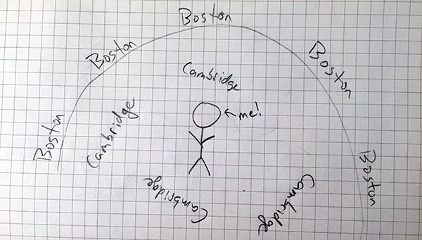
Subtended angle in this case means, more or less, how much of your 360º view contains the city in question. For example, where I live (artfully illustrated above), Boston occupies something like 270º—in other words, if I walk in a random direction from home, I’ve got a 75% chance of hitting Boston.
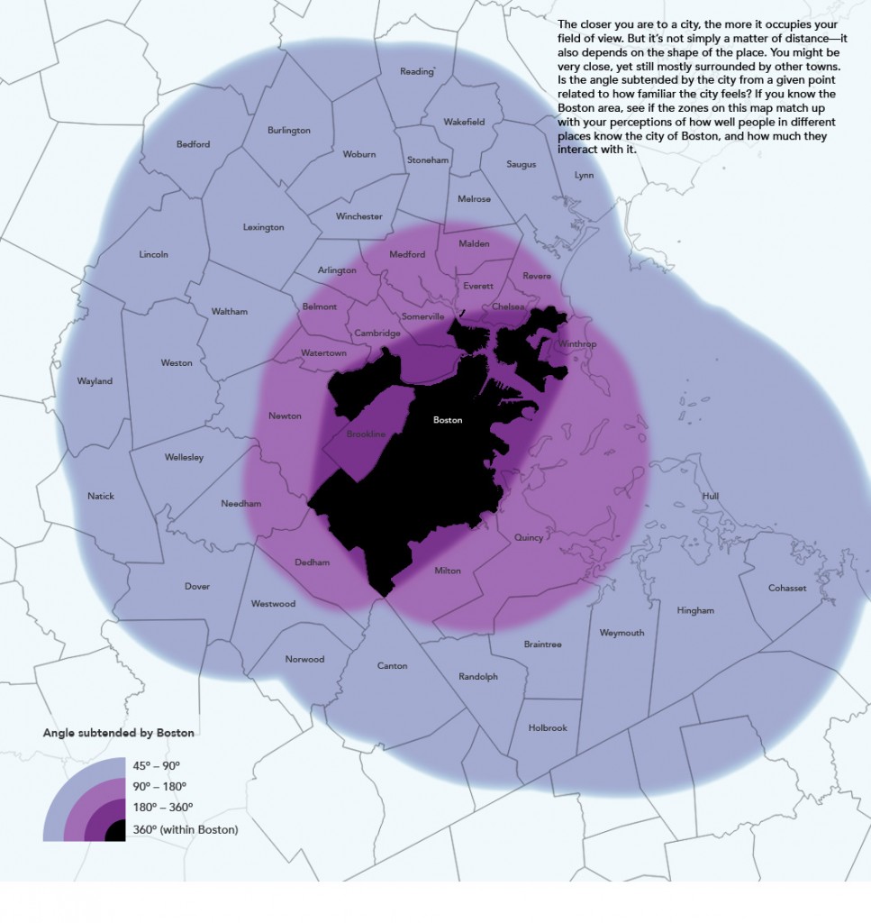
Subtended angle is in large part a function of distance, but it decays more quickly and then kind of levels out into a long tail. Furthermore, with an irregular shape it also depends on what side you’re on. Boston, for example, is longer in one direction than another, so it takes up more of the view from the east and west than from the north or south. The weird shape also means that some places near (but outside) the city are almost surrounded by it, while other places the same distance away are not even close to surrounded. I did some ugly raster math to make a map of this for Boston just to compare it to my perceptions of place (and place name usage) in the area.
Maybe Mike is onto something! In some ways the pink/purple areas match my idea of the “city” here better than a simple distance map would, and are areas where it might make sense to use sub-city place names when referring to Boston. Then again, most people probably have little idea of where the city limits are, so if subtended angle has any relation to how they think of and speak about the city, it’s probably all subconscious and dependent on which parts of the city they ever actually visit. And the whole thing is complicated by cultural barriers and peculiarities, at least around here where crossing the Charles River is often seen as journeying into the unknown, and where you’ll see plenty of signs pointing to “Boston” even within Boston.
Still, a fun thought/map exercise!


2 Comments