Beyond the sea

In the northern reaches of Newfoundland, near the town of St. Anthony, is the Fox Point Lighthouse. I’ve never been there, but I know it has one of the most impressive ocean views in the world. If you face perpendicular to the right bit of rocky coastline there and gaze straight across the ocean, your mind’s eye peering well beyond the horizon, you can see all the way to Australia.

Beach views of Australia map

What’s really across the ocean from you when you look straight out? It’s not always the place you think.

Across the oceans from the US

I’m inspired by a map done a couple of years ago by Eric Odenheimer and some follow-ups by Weiyi Cai and Laris Karklis of the Washington Post. Those maps are colorful, handy guides to countries of equivalent latitude across the oceans. It’s easy to forget, for example, that much of Europe is well north of the United States east coast. But they’re not exactly maps of what’s across the ocean from you, at least not directly across from you. To think of east or west as “straight” across is, perhaps, one of those effects of the map projections we see every day.

The latitude maps got me interested in answering the question more strictly: standing on a given point and facing perpendicular to the coast, if you went straight ahead, never turning, where would you end up? There are two reasons why following a line of latitude won’t answer the question.

1. Coastlines are crooked and wacky.
2. The earth is round.

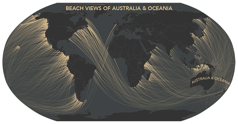
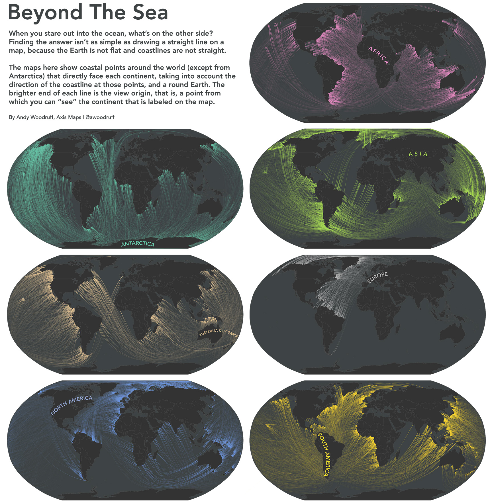
With that in mind, here are some maps showing the points from which you can “see” each of the continents.

Beyond the Sea

Coastline angle

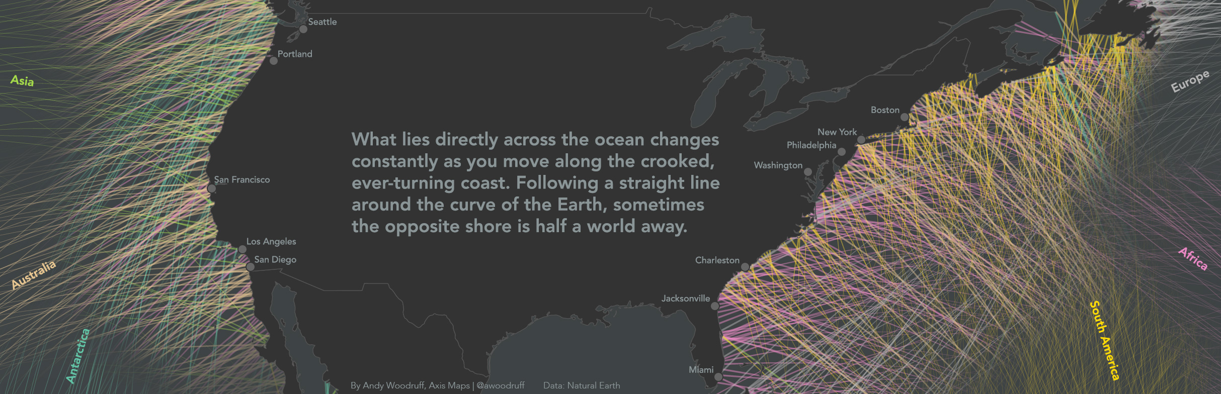
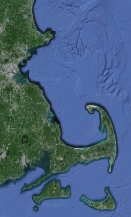
Coastlines face all different directions, bending and turning constantly. The “East coast” isn’t a straight north-south line facing directly east. Just look at the state where I live, which has coastline facing literally all directions.

Massachusetts coastline

Taking “across the ocean” to mean directly across, perpendicular to the coast, then what’s across the ocean depends on where you’re standing! To get a rough idea of what direction the world’s coastlines face, I’m calculating the angle between every pair of adjacent coastal vertices in medium scale Natural Earth data, then placing a point in between them and measuring the view from there based on that angle.

Points on coastline

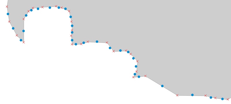
The much-maligned Mercator projection comes in handy here. Those angle calculations were made using projected coordinates because the conformal Mercator projection preserves the thing I’m interested in: local angles!

Straight lines on a round object

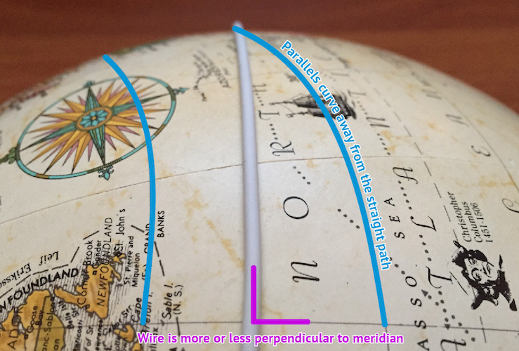
The second point is trickier to imagine thanks to common rectangular maps and the way latitude itself is defined. If you can detach the concept of “direction” from the concept of east and west, and look at globes and other map projections, it’s easy enough to picture. The shortest, straightest line on a sphere (let’s call the Earth a sphere even though it technically isn’t) is a great circle arc, not something like a line of latitude.

What we often think of as “straight” is a path following a rhumb line, a line of constant bearing. Wikipedia succinctly describes how such a “straight” line actually turns, in contrast to a great circle.

If one were to drive a car along a great circle one would hold the steering wheel fixed, but to follow a rhumb line one would have to turn the wheel, turning it more sharply as the poles are approached.

A typical classroom demonstration of great circles is to pull a piece of string taut on the surface of a globe between two points, and note how the string arcs across lines of latitude, changing its bearing the whole way. Try this specific case to drive home how the spherical “straight” differs from “straight” as we’ve defined compass directions: find a line of longitude on the globe, then a spot along that line somewhere away from the equator. Bring the globe to your eye and place the string perpendicular to the meridian, in between two latitude lines. Line up your view with the string and you can see that even though it starts out going due east or west, as it continues directly ahead the “straight” east/west parallels curve away from it.

Straight line on a globe

So if we want to know what’s truly straight across the ocean from a given coastline point, we need to see what direction the coast faces at that point, then draw a great circle in that direction and see what it runs into.

As for flat maps, certain map projections provide an accurate view of directions. The azimuthal equidistant projection, for example, preserves correct direction (and distance) from the center point of the map. A straight line from the center of the map is a straight line in real life. Here’s the Newfoundland-to-Australia example from earlier:

Straight line from Newfoundland to Australia

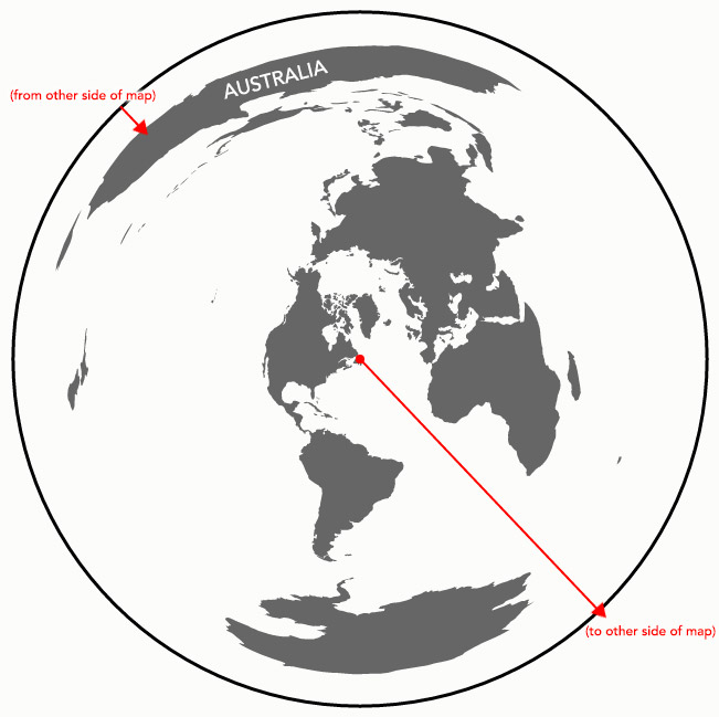
Such a map, in the end, is how I’m figuring out beach views: center that projection on each point, then draw a straight line in the correct direction until it hits land.

Conclusion

I’m not entirely certain that I have all the math right, but I think it’s at least close. Even we cartographers sometimes have a shaky grasp of map projections and spherical geometry.

But who has time for correct math? I’ve got to start training for the straight-line swim from the number one beach in my life—30th Street in Ocean City, New Jersey—to Brazil.

50 Comments

  1. Where in Brazil exactly? I can give you a hand once you get here!

    Pedro Guedes
    24 March 2016 @ 12:44pm

  2. I’m interested whether there are “mirror” coastlines, where if going in a straight line you would you bounce back to where you started. Similarly, a map of the bounces from a couple of select locations could be interesting.

    Thanks for the great work !

    Matthieu
    25 March 2016 @ 11:32am

  3. Great job! Did you find the longest line between two landmasses?

    Mikhail
    25 March 2016 @ 1:18pm

  4. This would also be of interest to surfers learning where their best waves might come from.

    Andrew Lee
    25 March 2016 @ 1:25pm

  5. Very nice! It could be nice to see whether any rays would be able to leave the Mediterranean.

    Akdeniz Akşamları
    25 March 2016 @ 3:28pm

  6. Why doesbthe Australian map shows some lines reaching Europe, whilst the European map does not show lines reaching Australia? Could it be due to granularity of coastal angle samples?

    Luis
    26 March 2016 @ 3:58am

  7. Luis – yes, in many cases like that it’s probably because of the simplified coastline angles I’m using. That said, a lot of the time it’s probably the case that the coast around those “destination” points simply faces in a different direction.

    Andy Woodruff
    26 March 2016 @ 10:00am

  8. Akdeniz – there is probably at least one point that can see out! From my earliest attempts at this I can vaguely recall seeing a line make it through the Strait of Gibraltar, but in the end I removed the whole Mediterranean for the sake of map clarity. Should have kept that one line on the map!

    Andy Woodruff
    26 March 2016 @ 10:04am

  9. Mikhail – my data aren’t yet in good enough shape to calculate that but I ought to! Supposedly the longest straight line in this fashion reaches from Pakistan to Siberia, but my maps omit anything that starts and ends on the same continent. Just from eyeballing these lines between different continents, I would guess that the longest one goes west from southern Africa and ends up in Siberia.

    Andy Woodruff
    26 March 2016 @ 10:10am

  10. Matthieu – that would indeed be very interesting! I’d guess that my data, being generalized, don’t contain any such “mirror” cases, but surely there must be some in the world somewhere, at least if you allow a little bit of rounding of the angles. Technically, even the slightest difference in angle between origin and destination points could result in vastly different “views” between the two places, as the lines stray farther from each other over great distances.

    Andy Woodruff
    26 March 2016 @ 10:17am

  11. It’s really lovely! I am wondering which software tools did you use? And are all the lines ‘drawn’ by code? And if so, do you use some sort of ‘intersect’ function to figure out where the path hits land on the opposite side of the ocean?

    Wendy Mak
    28 March 2016 @ 12:14pm

  12. There is a sign a Marine Corps Camp Pendleton “No beach out of reach” I just didn’t realize it was a straight line to get there.

    Colin
    28 March 2016 @ 1:05pm

  13. There’s a third way to “look across the ocean”… if I’m on the beach on the East coast North America, I’d be tempted to point my nose eastward (using a compass and despite the orientation of the coastline).

    I think this is different from your way, and also different than places along the same latitude.

    Dave

    David Swart
    28 March 2016 @ 2:37pm

  14. These are great. Is there any chance that you’d release any of these maps as posters?

    Jonathan
    28 March 2016 @ 9:44pm

  15. This would work better for the general public if created as a small programme or app. Place a point on a map (where you are standing)and illuminate all coastlines theoretically visible from that viewpoint. Probably work well if created as an AR app for smartphone.

    Baggins
    29 March 2016 @ 4:54am

  16. Be fun to calculate how high up our personal drone would have to be to see (line of sight) that other beach.

    grace
    29 March 2016 @ 3:22pm

  17. Would be nice to see one where New Zealand isn’t on the far edge of the map! Though we often get cut off altogether…

    David
    30 March 2016 @ 2:26am

  18. while we’re tossing aout augmentive ideas … i wonder if there’s a place on the sea where one can stand and see the back of one’s own head.

    agamemnon
    30 March 2016 @ 3:34am

  19. while we’re tossing out augmentive ideas … i wonder if there’s a place on the sea where one can stand and see the back of one’s own head.

    agamemnon
    30 March 2016 @ 3:34am

  20. Mattheiu – no, a “mirrior” coast is impossible. The closest you could get would be a very thin strip of land where going in a straight line ends up back at the coast directly behind you.

    Remember that, despite what happens when you look at projections, the lines are in fact straight. Imagine them as great circles on a globe (or if you have a globe handy, just draw them out) and you will see that a mirror effect is impossible. The great circle reaches its starting point coming from behind, not in front.

    Sam
    30 March 2016 @ 8:31am

  21. Would be amazing to have a website where you could enter your location and get the resulting line generated.

    Rich Stamper
    30 March 2016 @ 1:18pm

  22. These are beautiful. Thank you. I’ve often gone to the ocean when I’m travelling to “send a message” across the water to home and wondered where the theoretical message ends up. I agree with the people who want to be able to enter a location. It would be so interesting if someone could create this. Thank you again.

    Darlene
    30 March 2016 @ 1:54pm

  23. Is there any place we can download higher res versions of any of these maps? Particularly interested in North America.

    Great work.

    Will
    30 March 2016 @ 3:20pm