
Squeezing San Francisco
Here’s an interesting map I picked up in San Francisco last year. (Forgive the poor-ish quality. I laid it on the floor and took a photo of it.)
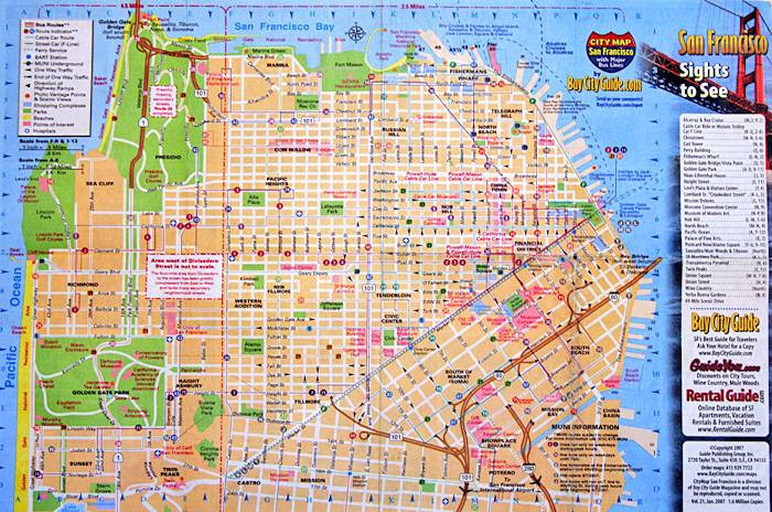
It took a while to realize this, having referred mostly to the downtown area in which I was staying and because the shape doesn’t look too unusual at a glance from a non-local, but the map is actually at two different scales.
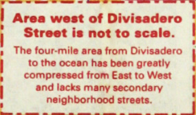
The dashed red lines indicate the different scales. The section on the left is 4.5 miles across while the larger section on the right is 2.5 miles across. It’s fascinating because (1) unlike an ordinary inset map, the two differently-scaled areas are adjacent and contiguous and (2) it’s only the horizontal scale that differs. I’d never seen anything like this before. The closest thing I can think of is certain subway maps, such as the updated Vignelli map of New York subways with a tiny Staten Island, but really those are a different animal, often falling in the category of cartogram.
I think I like the idea as a way to show the whole but focus on one section (ostensibly more important for tourists), but then I didn’t attempt to get around anywhere in that western section, so maybe it would actually turn out to be frustrating. San Francisco, it seems, is probably a rare city for which it’s easy to pull this off: it ends abruptly at water on three sides and has a street grid largely aligned to the cardinal directions, meaning the map can be squashed horizontally while preserving most street angles. Are there other maps like this out there?
A PDF of the map is available at Bay City Guide’s site.
Tagged interesting maps, san francisco, scale
1 Comment