
Revenge of the Valentine’s Day map
A year ago I fired off a quick post with a world map in the Werner projection, which of course we all know is heart-shaped and the ultimate expression of love. In the hopes of establishing a stupid annual tradition, I wanted to do another map this year, and after concluding that simply projecting or arranging maps into heart shapes has been played out, I decided to work for it this time.
Let’s cut to the chase. I traveled a path around town in the shape of a heart as best I could. It was 10.44 miles (that’s 9,872 smoots in the local system of measurement), and the reason it’s awesome is that part of it was on a boat. The GPS track became this sickly shape—not exactly an ideal heart but vaguely recognizable as one. Or at least some kind of pointy muffin. [Google Maps link]
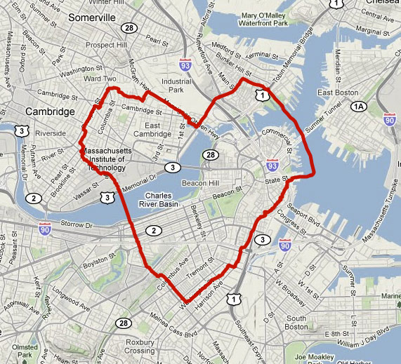
This is my first foray into GPS drawing, and I certainly don’t expect to reach, say, Jeremy Wood‘s level of mastery of the art. But it’s not so much about the art; while this is indeed an attempt at a silly Valentine’s Day map, it is also an exercise in what has been my Cartographic Purpose lately. More and more what interests me is the idea of maps as drivers of activity in physical spaces, particularly as it relates to exploration and discovery in cities as well as personal construction of place and mental maps. My zombie and personal mapping posts touch on this—the map represents in its ordinary capacity the real world but in another capacity a fairly abstract, meaningless space that is acted upon in the real world. So I am driven toward or away from a place not because of what is actually there, but because in some virtual space it contains a zombie or because it is a blank spot on a map of lines or because it happens to be within a heart shape on a street map; and then I discover what is there. Some day when I collect my thoughts and do some more background research I’ll write more about this practice. For now suffice it to say that I am fascinated by this method of discovering and creating place.
For the actual report on this heart excursion you can check out my Bostonography blog post, as they are probably too Boston-specific to address in any detail here. Except this one. Yes sir, mister billboard!
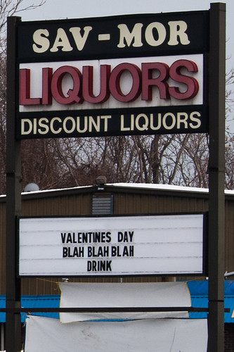
(As long as I’m tying all this into older posts, remember that city boundaries are stupid. This liquor store is in a border zone and I am really not sure which city it’s in. Could easily find out, but now I refuse to.)
Tagged Boston, gps, place, valentines day
8 Comments