Current diversions: metro maps and self maps
Two ongoing things are keeping me entertained in my spare time these days.
AUTOMATED METRO MAP GENERATION
Metro or subway maps are cool. They’re simple, effective topological diagrams showing you how to get from Point A to Point B in the system. And, I might add, they make great symbols of the cities whose metro systems they depict. (This, of course, has most successfully been the case with the famous London tube map.)
There’s usually a lot of manual labor involved in designing these maps, but they’re also an obvious candidate for automated layout attempts. I wouldn’t waste my time trying (and failing) to invent some algorithm, as more brilliant people before me have done so much better than I could, but I am interested in implementing one for some sort of tool that can be fed a KML or other geodata and spit out a simple metro map-like diagram.
I’m currently in the early stages of working through the method devised by Jonathan Stott for his Ph.D. thesis (25 MB PDF).

Above is some early progress on a single subway line, a branch of the Red Line of Boston’s MBTA (or “T” if you like). It’s not great yet, but I’m not done yet. (Gotta get rid of those 90-degree turns!) In the end I’m hoping that I’ll be able to produce a map of any network of lines and nodes, be it a subway system, roads, or what have you. Stay tuned, and I’ll post when I have made some actual progress.
POOR MAN’S GPS TRACKS
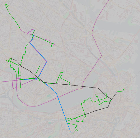
Speaking of transportation, the other mini-project is to keep track of everywhere I go and the mode of transportation to get there. I’m not carrying a GPS receiver everywhere, but I do keep unreasonably detailed memories of all my travel paths (at least for a short time). I’m hoping that after a while this map might be mildly interesting because 1) I work from home, so my trips are somewhat irregular in both timing and destination, and 2) my movement around town is pretty multimodal.
Here’s most of my January so far. (Green: by foot, Purple-ish: by car, Blue: by bus, Black: by subway)

Hoping this will make for a sweet animation after some months. But you’re right; it’s probably stupid.
Tagged Boston, map projects, metro maps

5 Comments