A personal map of 2010

My tracks in central Boston and Cambridge in 2010

A number of year-end retrospective blog posts in map-related fields have appeared in the last week or so, and it’s been interesting to take stock of all the excellent work people did during 2010. I of course didn’t do anything worth mentioning; I just went places and mapped it all.

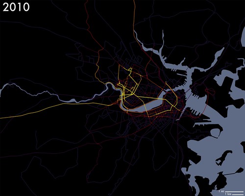
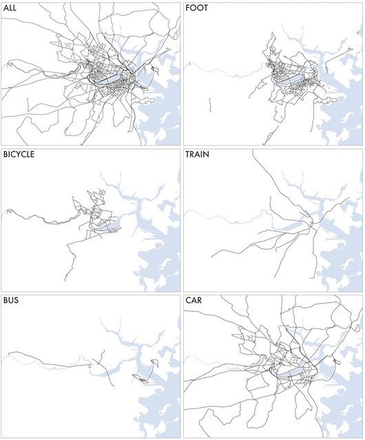
Like I did last year, I have collected all my travels within the immediate local area (Boston) into a series of maps categorized by the mode of transportation for each trip. These are not GPS tracks; I remain low-tech and manually record each trip on a map. Any given segment has a line drawn once per day per mode of transportation. So, for example, if I walked one direction along a street and then later returned on the same street, I recorded only one line there for the day; but if I walked down the street and then returned on the subway running underneath the street, I recorded two lines. So the following neon map that ostensibly uses color intensity to show frequency of travel (blue = less, yellow = more) is really more of a compiled daily log than an accurate record of my presence at every location.

2010 tracks with intensity

Maps for the various modes of transportation are in a small Flickr set. Those are foot, car, train, bike, and bus. No animation this time; that’s too much work.

2010 tracks by mode of transportation

As usual there is no real purpose to this hobby, but it is an interesting exercise in personal geography. For me, relatively little movement around the city is governed by routine because I work at home. I had a once-a-week job during the fall and had my usual grocery stores and such, but otherwise it’s almost all personal choices. I can look at the map and ask myself why I went where I did or why I didn’t go to the empty spaces on the map. I can identify the paths that indicate patterns in my life where I thought there were none. And of course I can look for signs of things like Kevin Lynch-style mental mapping concepts.

The most valuable thing about this habit, though, is not the post-mapping analysis but rather the motivation it generates to get out and explore and get to know new parts of the city. I’m sure you can imagine the thrill of getting to draw a line on a new part of the map. Doing all this without GPS keeps my mind sharp, too, because I must always be aware of exactly where I am so that I can later mark it on the map. My local expertise in transportation and geography is skyrocketing because of this little project. I highly recommend that everyone live cartographically!

Resolution for 2011: ride a boat.

Tagged , ,

14 Comments

  1. Another resolution: get thee on the Minuteman Trail!

    Golden Guns
    3 January 2011 @ 9:18am

  2. “My local expertise in transportation and geography is skyrocketing because of this little project”
    I like this, I think I’ll do something similar this year

    zioluc
    3 January 2011 @ 9:48am

  3. I like how you’ve mapped out where you go and how you differentiate between which methods you use to get to your destinations. I’ve been playing around with Google Latitude and like recording where I go so I can find patterns like the ones you did above. Great post!

    caffeind
    3 January 2011 @ 11:46am

  4. Here is mine, not as clean as yours because recorded with GPS
    http://picasaweb.google.com/tarmo888/January22011

    Tarmo
    3 January 2011 @ 12:08pm

  5. Wow, what a labor of love. Did you seriously spend in a year in the Boston metro area without driving on Route 128? How subversive.

    Matthew Heberger
    3 January 2011 @ 12:12pm

  6. Matthew – Those maps don’t actually extend as far as 128 except a small piece of it (which I did happen to hit). Even so, I could definitely count on one hand the number of times I was on that road in the past year. It’s been pretty fascinating to see that my life mostly seems to take place either within about 5 miles of home or a few hundred miles away. Route 128 is somewhere in between.

    Tarmo – Thanks for sharing! It’s great to see other people’s maps, even if only to know that we are all in good company.

    Golden Guns – Good call. I rode out there a couple of times in 2009 but then apparently got lazy or something for a whole year.

    Thanks for the comments, all!

    Andy Woodruff
    3 January 2011 @ 2:46pm

  7. Bicycling is really one of the best ways to explore unfamiliar places. I recommend getting over to Castle Island and riding the somewhat disconnected web of paths along the east side of Boston down to and up the Neponset River. It’s a little dicey getting to the shoreline from any other part of the city but very doable. Also, it looks like you may have missed the Southwest Corridor.
    A ride on the Silver Line can also be fun and educational-less so if it’s your daily reality.

    Dug
    5 January 2011 @ 10:13am

  8. Dug: It’s interesting—with about three exceptions all my bike-riding in 2010 was about getting to some destination (even the excursion down into Brookline). I can get on board with bicycling as a way to explore, but I’m more partial to walking if the distance (from home or from transit) makes sense, as the pace is better for absorbing more of the surroundings. That said, your suggestion of riding along the shoreline is a good one for when warmer weather rolls in!

    I’ve never ridden the Silver Line apart from the airport branch, although I’ve covered most of the routes on foot. I’m curious what makes it fun and educational!

    Andy Woodruff
    6 January 2011 @ 12:04am

  9. Silver Line – I just like that you see areas and things you might not otherwise see. On the airport part you get some of that wacky big dig infrastructure. The Roxbury part is interesting because I don’t get to that neighborhood much and there’s lots of history, architecture and cultural stuff that you don’t get in other parts of Boston.

    Dug
    6 January 2011 @ 8:52am

  10. This is fascinating stuff. Well done for the dedication – you’re a true geek hero! Recording data in analogue style is truly dedicated.

    Do you have the source data electronically? Maybe I could animate it for you?

    Andy Cotgreave
    12 January 2011 @ 4:20am

  11. I’m glad to see somebody else doing something similar! After a big trip in 2007 where I didn’t bring a GPS, I’ve gotten in the habit of bringing it everywhere new.

    http://www.kelvinism.com/travelmap/

    I’ve contemplated making such capability into a small free service (i.e. uploading GPX tracks and getting a map), but need to change the GPS tracks to images, instead of rendering them via KML.

    Kelvin Nicholson
    17 January 2011 @ 3:35pm

  12. Did you fly out of Logan at all? Here’s a gps of a recent flight out.

    http://2.bp.blogspot.com/-qN-4wkLsKhs/UsJU1yVznCI/AAAAAAAAAJ4/7QJNAycHtH4/s640/logan.png

    Greg Krathwohl
    31 December 2013 @ 12:25am